Tag: water management

Podcast 66: The UK National Grid: history of an energy landscape and its impacts

Pylons

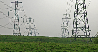
Electricity Pylons. Source: Geograph.org.uk

We take electricity for granted and do not think of where it comes from when we switch on a light or use an electrical appliance. But behind the electricity coming out of a wall socket lays an entire energy landscape of poles, wires, electrical substations and power stations. It is imposed on the landscape like a gigantic web, a grid that has become almost part of the natural scenery.

Just over a century ago this electricity grid did not exist. Power generation was local or at best regional and often based on the burning of coal or the use of locally produced gas. In less than a century the grid covered the entire United Kingdom and many other countries. It revolutionised our lives, the way we worked and it made air in cities a whole lot cleaner. But how did the development of this energy landscape impact on the landscape and environment? What were the social and economic consequences of the expansion of the grid?

This history is now researched by Cambridge based PhD candidate Kayt Button. Her project is part of the British Arts and Humanities Research Council funded environmental history initiative “The Power and the Water: Connecting Pasts with Futures”, that focuses on environmental connectivities that have emerged in Britain since industrialisation. Episode 66 of the Exploring Environmental History podcast features Kayt’s work and discusses the development of the UK National Grid, and how it changed people’s lives, its environmental impacts and how the past informs the future development of the grid.

Websites mentioned & other resources
The Water and the Power Project website
Blog posts & poster by Kayt Button
Exeter Memories: Electricity Generation in Exeter
South Western Electricity Historical Society
UK National Grid at 75

Music credits
Dance of the Pixels” by Doxent Zsigmond, available from ccMixter
Snowdaze” by Jeris, available from ccMixter

The production of this podcast was supported by the Water and the Power project and the AHRC.
AHRCPower and the water

Podcast 65: Environmental history of a hydrological landscape: the soughs of Derbyshire

Sough tail

Sough tail (Photo: Georgina Enfield)

Under the Peak District of Derbyshire is a subterranean network of drainage tunnels, the so-called soughs that were used to drain the lead mines of the region

Up till the 16th century most lead mining In the Peak District done on the surface and miners followed horizontal seams. By then the surface seams were exhausted and miners had to sink shafts to reach rich underground seams. By the 17th century most mines were down to the water table. To prevent the mines from filling up with water drains or ‘soughs’ were cut through the hills to a neighboring valley. The construction of soughs changed the hydrological landscape of the Peak District, both below ground and above. In some cases the soughs not only drained mineshafts but also the small rivers above, which as a result were dry most of the year. The construction of soughs also reduced the flow of watercourses powering the mills of the early Industrial Revolution. This led to legal conflicts between sough builders and others who relied on the availability of water. Petitions were submitted to the courts and many of these court cases rumbled on for decades.

During the 20th century the soughs were largely forgotten but recently the soughs have been rediscovered for their industrial heritage on the one hand, and their detrimental effect on the hydrology of the landscape, pitting heritage values versus ecological restoration, creating a new battle ground of interests.

This edition of the podcast examines the environmental history of the Derbyshire Soughs with Carry van Lieshout, a historical geographer at the University of Nottingham. She works on a research project that investigates the environmental and cultural history of the Derbyshire soughs in order to inform understandings of this largely forgotten cultural landscape and to develop management and conservation strategies for underground heritage.

Website mentioned
The Water and the Power Project website

Further reading
From Lead to Tail: an Environmental History of the Derbyshire Soughs. Poster presented by Carry van Lieshout at the World Congress of Environmental History in Guimarães, Portugal, July 2014.

Peter Coates, Who killed the Lathkill? (or, when is a river is no longer a river?), The Power and the Water blog, 5 Nov. 2014.

T. D. Ford and Rieuwerts, J., Lead miners’ soughs in Derbyshire, Geology Today, 23 (2007): 57–62. doi: 10.1111/j.1365-2451.2007.00604.x

Music credits
Like Music (cdk Mix, 2013 & 2014)” by cdk, available from ccMixter

The production of this podcast was supported by the Power and the Water project and the AHRC.
AHRCPower and the water

Podcast 49: Kielder: the story of a man-made landscape

Kielder houses

Former Forestry Commission workers houses in Kielder Village withforestry plantations in the background. Source: geograph.org.uk/Stephen Richards.

Around the world, rural landscapes have been transformed by human activity as never before. In England, one of the most striking locations of such anthropogenic changes is Kielder Forest and Water in Northumberland. Since the 1920s, this site has seen a massive tree planting effort, creating one of the largest man-made forests in Western Europe. During the 1970s a large dam and reservoir were constructed at Kielder in order to create a secure water supply for the industries at Teeside. As a result Kielder has witnessed significant and dramatic environmental changes over the course of the twentieth century, as it was transformed from a pastoral agricultural landscape, to that of a commercial forest and finally it received the addition of a large man-made lake.

Construction Kielder Reservoir

The construction of Kielder Dam
and Reservoir. Source: Wikimedia Commons.

To tease out how people have experienced and perceived the man-made environment of Kielder, the Kielder Oral History Project was conducted. On this episode of the podcast, the two researchers who carried out the Oral History project, Professor David Moon of the University of York and Dr Leona Skelton of Durham University, will discuss some of their findings.


Books and articles mentioned

Christine McCulloch, Dam Decisions and Pipe Dreams: The Political Ecology of Reservoir Schemes (Teesdale, Farndale and Kielder Water) in North East England (Saarbrücken: VDM Verlag, 2008)

R. McIntosh,’The history and multi-purpose management of Kielder Forest’, Forest Ecology and Management, 79 (November 1995) 1–2, pp 1–11.

Ruth Tittensor, From Peat Bog to Conifer Forest: An Oral History of Whitelee, its Community and Landscape (Chichester: Packard Publishing, 2009).

Relevant links
Kielder oral History project report
Kielder Village Website
Kielder Water and Forest Park website
Kielder Water Wikipedia page
Kielder Forest Wikipedia page

Music credits

Memories of an Old Dog” by Fireproof_Babies
Available from ccMixter

Where You Are Now” by Zapac
Available from ccMixter


Acknowledgements:
The interviews were conducted by Dr Leona Skelton at Kielder during the week 15-19 October 2012. We would like to acknowledge the support of Northumbrian Water plc, especially Andrew Moore and Tonia Reeve, the Forestry Commission, in particular Graham Gill, Julie and Steve Webb of the Kielder Village Store, Duncan Hutt of the Northumberland Wildlife Trust, and the staff of the Calvert Trust Kielder for their assistance in setting up the interviews and, especially, all those who agreed to be interviewed.

AHRCThe Kielder Oral History Project and the production of this podcast was funded by the AHRC Landscape & Environment Programme.

This podcast was simultaneously published on the Histories of Environmental Change website.

Podcast 48: Remaking wetlands: a tale of rice, ducks and floods in the Murrumbidgee River region

Murrumbidgee Map

Map of the The Murray-Darling river system with the Murrumbidgee river in red. Source: Wikipedia

Australia is a dry continent and as a result Australian ecologies can generally be characterised as “boom and bust” and are significantly driven by intermittent and unpredictable wet “booms” and dry “busts”. The populations and movements of many animals are considerably influenced by these wet and dry periods. Birds tend to be “nomadic” and go where the water is. Native Australian ducks are no exception.

Before the arrival of Europeans and their agriculture, ducks only had to compete with other native birds and animals, as well as Aboriginal hunters.

Anas gracilis

Grey Teal (Anas gracilis).
Source: Wikimedia

However, the introduction of water intensive agricultural activity by Europeans changed all this and in particular rice cultivation has been implicated in altering the Murrumbidgee river system in Australia, and as a result the habitat for ducks. The guest on this episode of the podcast is Emily O’Gorman, an Associate Research Fellow at the Australian Centre for Cultural Environmental Research of the University of Wollongong. She is an expert on Australian flooding and river history and examines on this podcast the ways in which ducks as well as people negotiated the changing water landscapes of the Murrumbidgee River caused by the creation of rice paddies.

Information on Emily O’Gorman’s book 
Flood Country: An Environmental History of the Murray-Darling Basin – Info from the Publisher.

Music credits

Forecast” by cdk
Available from ccMixter

Where You Are Now” by Zapac
Available from ccMixter

Podcast 38: The draining of the East Anglia Fens: social unrest, design flaws and unintended environmental consequences

This episode of the podcast examines the history of the Fens, a region of wetlands in East Anglia in England. The Fenland primarily lies around the coast of the Wash in the Northern top of East Anglia.

The Fens are at or just above sea-level and, as with similar areas in the Netherlands, much of the Fenland originally consisted of wetlands which have been artificially drained since the Middle Ages and continue to be protected from floods by a system of drains, dams and pumps. Much of this work was carried out during the 17th century. With the support of this drainage and coastal protection system and because of its fertility, the Fens have become a major agricultural region in Britain for grains and vegetables.

The story of the reclamation of the fens is one of social unrest, design flaws, money problems and unintended environmental consequences. The guest on this episode of the podcast is Julie Bowring, a PhD candidate at Yale University and she is in the final stages of writing up a dissertation on the so-called Great Level of the Fens in Cambridgeshire, England.

Map Great Level

Development of the Great Level, 1503-1658. Map: Julie Bowring/Wikipedia

Website mentioned 
Histories of Environmental change

Literature cited
H.C. Darby, The Draining of the Fens (Cambridge: Cambridge University Press, 1940)

Music credit
The Pond ” by Chuck Berglund
Available from ccMixter

Dutch river defences in historical perspective

After the storm surge flood of 1953 the Dutch water management authorities (Rijkswaterstaat) decided upon an ambitious plan to reinforce and increase the height of all dikes and levies in the Netherlands. This not only included sea defences but also river dikes. The project started in the 1960s but initially only sea defences were reinforced and the river area in the centre of the country was dealt with a few years later. Continue reading

Industrial water pollution in the Groninger Veenkoloniën, 1850-1980

Introduction

Location of the Ven Colonies.

Location of the Ven Colonies.

In the north of the Netherlands, in the province of Groningen, is an area called ‘De Veenkoloniën’ (The Ven Colonies or Peat Colonies). This area once provided the main energy source of the Dutch Golden Age: peat. During the period between the beginning of 16th trough the start of the 20th century the peat moors were drained and cut away. In the second half of the 19th century the peat in the Veenkoloniën was almost gone1. What remained was a unique landscape dominated by huge fields and straight canals. This landscape formed the foundation for the agricultural industry that emerged in the second half of the 19th century, with potato starch and strawboard as their main products.

The emergence of the agricultural industry in the Groninger Veenkoloniën caused a quite serious problem: one of the worst episodes of industrial water pollution in the Netherlands. This gave the Veenkoloniën the negative image of a region with filthy and stinking canals, being the concern of the industry, government and population for more than a century. Continue reading

THIS WEBSITE USES SOME COOKIES.

Please confirm, if you accept our tracking cookies. You can also decline the tracking, so you can continue to visit our website without any data sent to third party services.

Read our Privacy Policy for more information about the cookies used.