After the storm surge flood of 1953 the Dutch water management authorities (Rijkswaterstaat) decided upon an ambitious plan to reinforce and increase the height of all dikes and levies in the Netherlands. This not only included sea defences but also river dikes. The project started in the 1960s but initially only sea defences were reinforced and the river area in the centre of the country was dealt with a few years later.
When it became clear during the 1970s that the heightening and reinforcement of the river dikes affected the landscape in a negative way people started to resist the reinforcement programme. One of the results of the programme was that some historical villages and farms had to be demolished and the concrete and asphalt “walls” that appeared changed the character of the river delta landscape. The water management authorities ignored the protests and argued that landscape values had to be sacrificed in return for safety.
However, by the early 1990s the dike reinforcement programme had done some significant damaged to the landscape and the minister for public works and transport appointed a commission to investigate if security against floods could be achieved in a less destructive manner. It also considered if lessons could be learned from the past because the river region in the Netherlands has been managed for over a thousand year.
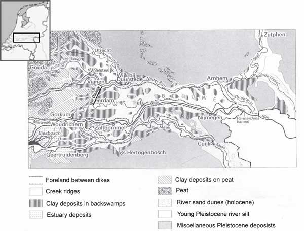
Map 1: Location and geography of the Dutch river area.
Development of water management, 1000-1800
The earliest inhabitants of the river area between the branches of the lower Rhine and the Maas Rivers settled elevated former river channels called creek ridges (stroomrug). These old river channels are separated by the lower laying areas called “komgronden” (roughly translated: bowl-grounds) or backswamps, which flooded during the winter but were used for grazing during the summer season. This situation lasted until about the 10th century when the population started to increase more rapidly and more agricultural land was needed. This was during the climate optimum, a period of more benign weather and fewer floods. As a result of the population pressure and encouraged by fewer floods, lands away from the rivers were drained and cultivated, which led to subsidence of the land and thus making it more prone to flooding. In response to this people started to protect themselves from the river floods by constructing levies running away from the river at right angles in order to deflect floodwater coming down the river. These so called “zijwenden” or side dikes were later connected with levies parallel of the river, the so called “achterwende” or rear dike which prevented water from flowing into the lower laying “komgronden”.1
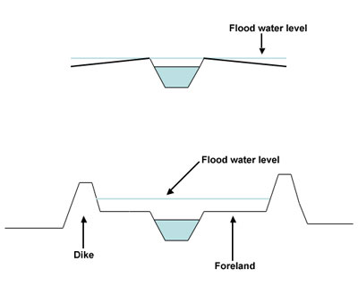
Figure 1: diagram of river with and without dikes.
The next stage in the fight against river flooding was the construction of dikes in the 12th and 13th centuries. The dikes were constructed away from the river in order to create a foreland (uiterwaarden) that acted as a buffer to store floodwaters and were used as a water meadow during the summer months. This measure prevented the annual flooding but over time it created a whole host of new problems.
Every year that the river flooded new material was deposited between the dikes and as a result the riverbed was slowly but steadily lifted above the floodplain and the water storing capacity between the dikes was being reduced. In response the dikes were increased in height but by doing so the hydrostatic pressure of floods also increased because the water could rise higher between the dikes. This led over time to an increasing number of dike breaches and catastrophic floods. An additional problem was that dikes were not everywhere reinforced and increased in height at the same time. This led to a situation that if a town or landowner at one side of the river increased the height of the dike, people on the other side of the river had to do the same or risk water flowing over their dike in case of a flood.
An additional problem of the construction of river dikes was the formation of sandbanks in the river, obstructing the flow of water. During floods the river channel could not carry al the water and as a result the dikes overflowed inundating the lower laying area behind the dike. However, a more serious threat was the formation of ice jams in the river during very cold winters, which led to the formation of ice dams, and a rapid rise of the water level. The majority of floods during the height of the Little Ice Age in the 17th and 18th centuries were the result of the formation of ice dams. There was not much that people could do about ice dams, apart from improving places prone to ice jams such as narrow parts of the rivers and sharp bends. Sometimes explosives were applied in attempts to remove ice dams.

Figure 2 : The principle of side and rear
dikes (zijwende).
In order to escape the increasing number of severe floods people started to construct mounds during the 13th century. The construction of these mounds did not precede embankment construction but were a response to the problems caused by the construction of dikes. A second response was the construction of transverse dikes, which were meant to stop floodwaters coming from the east. The most well known example of these transverse dikes is the so-called Diefdijk, which was constructed during the 13th century on order to protect the lower reaches of the Rhine delta. This reduced flooding downstream, but increased it upstream, in the east of the country Figure 2). This was obviously not in the interest of the people who lived to the east of the Diefdijk and did not exactly encourage co-operation to deal with river flooding.2
Another strategy that developed over time was the construction of overflow and lateral diversion channels. An overflow is a deliberately lowered dike section that could be easily and quickly lowered further as an emergency outlet in cases of dangerous high water levels. The overflowing water was then channeled over land, sometimes between low dikes, downstream to another section of the river or an entirely different river. In some cases the water was directed to low laying not build up land that functioned as a retention basin. During the 18th century the overflow and lateral diversion system became central to flood management in the Dutch river region and spillways, channels and retention basins were carefully planned. The downside of this system was that significant areas of land could be underwater for several months per year making it useless to farmers.3

Dike Breach and flooding in the early 19th
century. Source: Rijksmuseum Amsterdam
River flood management in the 19th century
By the mid-19th century a flexible river management system had developed that did not resist floods but controlled it by increasing the capacity of the river by adding extra flow channels in the form of the overflow and lateral diversion system that channelled the water into retention basins or downstream. However, technical developments in hydrology, construction technology, and steam engines led increasingly to a more technocratic approach to water management. The flexible approach with the use of spillways, to give water space when it was needed, was replaced by a strategy that resisted the water.
The transition from the dynamic to the resistance system can be observed in the work of hydrological engineer J.H. van Rechteren. In 1850 he published a book in which he advocated a dual system of resistance and dynamic solutions in order to protect the low laying land in the river area. He made the following recommendations:
- Improvement of the riverbed, i.e. making it deeper en smoother.
- The use of spillways and temporary channels.
- Reinforcing and increasing the height of dikes.4
During the 19th century so called improvement projects were carried out that implemented van Rechteren’s ideas. The riverbeds were dredged, river channels were straightened and kept in place with so called groynes (kribben) and secondary channels of the river were dammed off from the main channel. The aim of this engineering work was to increase the current and let the water flow off as fast and smooth as possible to reduce the risk of high water levels. An increase in the flow speed also prevented the formation of ice and ice dams and the formation of shallows.
In the second half of the 19th century the number of spill channels constructed declined since the believe took hold that the flooding of useful agricultural land had to be minimised. Around the turn of the 20th century most spillways were closed and the river defence strategy adapted was that of the resistance and control type: higher and heavier dikes and locks to control the water and protect valuable agricultural land, towns and villages. The main reason for this shift in thinking was the fact that the disruption of flooding and the economic damage to farming was not longer regarded as acceptable.
The 1950s and beyond
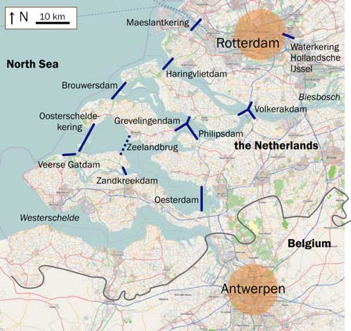
Delta Works, Zeeland, The Netherlands.
Source: Wikimedia Commons
Around 1950 the overflow and lateral diversion systems had been closed for decades. The dualistic approach combining flexible and dynamic systems had been replaced by a system of rigid flood defenses that aimed at keeping water between the dikes and levies as well as management of the water flow. The latter was aided by the construction of a series of locks in the river. On both sides of he river low summer levies protected the foreland, which is used as summer grazing and at a larger distance from the river lies the winter or main dike to protect the hinterland. That is how the rivers in the Dutch delta looked around 1950.
In the night from 31 January – 1 February 1953 the Dutch coast was hit by a hurricane force storm that inundated large areas in the western part of the country. The damage was enormous and over 1800 people lost their lives. In order to prevent such a catastrophe in the future the Dutch Government introduced a plan that aimed at reinforcing the water defenses and to shorten the coastline by closing estuaries with large dams. This plan became known as the Delta Plan. This huge project aimed at protecting the coast in a manner that reduced the risk of a disaster such as the 1953 flood to a probability of one in 3000 years. However, the Delta Plan was not just limited to the coastal areas but stretched along the rivers all the way up to the German border.5
The construction of dams in the estuaries led to an unexpected problem that increased the need to reinforce and heighten the river dikes and levies in the hinterland. The closure of the estuaries led to a slower discharge of the river into the North Sea and an accumulation of sediment in the rivers resulting in shallower river channels and the need for higher dikes.6
Resistance to dike reinforcement
The reinforcement of dikes in the river area of the Netherlands began in the 1960s. Soon levies the size of major coastal flood defences appeared in the landscape; many historical houses were demolished to make place for dikes clad in concrete and basalt. Soon this kind of river dike reinforcement attracted heavy criticism from the local population that saw the historical character of the river landscape change drastically. Most painful was the fact that many houses had to make way for the new concrete and basalt clad levies.
In 1976 response to this criticism the minister of public works appointed a committee to look into the ways that the dike reinforcement in the river area was conducted. This committee, better known as the Becht-commission, published its findings jus over a year later. This report suggested that the dike reinforcement programme in the river area needed to be reconsidered and made the following recommendations:
- To lower the inundation protection from once in 3000 years to once in 1250 years.
- To give more consideration to historical and aesthetic landscape values. A dialogue about these issues with the local population was seen as desirable.7
The water management authorities politely ignored the report because this it required them to radically change their strategies and outlook on issues related to water management and flood protection. The dike reinforcement programme as envisaged in the Delta Plan continued as if nothing had happened. It would take another two decades until another minister of public works listened to the protesters and installed a second committee to look into the issues of river dike reinforcement. This committee became known as the Committee Boertien, after its chairman. The remit of this committee was to examine if there were any alternatives to the reinforcement of dikes in the river area and whether the Delta Plan had to be adjusted accordingly.8
In its final report committee Boertien concluded that the water authorities had wasted sixteen years by avoiding any discussion about the damage that the dike reinforcement programme was doing to the river landscape. According to the report this had to change and the opinion of the local population had to be taken into account before any work was being undertaken. It concluded that the river landscape was the result of centuries of interaction between humans and nature which had created a unique landscape. When destroyed this landscape could never be restored in full and would also result in the loss of habitats for plants and animals. Nature can be partially redeveloped but the cultural and historical context in which the former landscape was formed would never repeat itself. However, the report stressed that landscapes are not static and that proposing to freeze it as it is would also be unrealistic.9
Ice jams
An interesting objection against the heightening and reinforcement of dikes came from an unexpected quarter. After some in depth research engineer Berveas, chair of the historical foundation Bommelerwaard, a region in the river area, concluded that ice jams had caused most floods in the past. As discussed above ice jams form when drift ice from upstream gets stuck on a bent or shallow of the river obstructing the water flow. The water behind the dam starts to rise and pressure on the dikes increases and inevitable the water flows over the dike. After a few days the dike is so saturated by water and weakened by the hydrostatic pressure that it will collapse.
Increasing the height of a dike and reinforcing it is useless in the case of ice dams. When the height of dikes increases so will the height of ice dams and water will flow anyway over the dike and weaken it, with more devastating consequences because of the increase in the hydrostatic pressure, making any water that is released during a dike breach even more destructive.10
The response of the water authorities to Berveas’ ideas was that ice jams are unlikely in the present warmer climate. In addition they pointed out that straightening and dredging of the rivers makes the rivers flow faster and ice formation less likely. However according to Berveas these arguments do not hold since a warmer climate does not exclude the occasional “Siberian winter” in the Netherlands. In his opinion it is ludicrous to argue that we will not see such winters in the next 50 years, not to mention in the next 1250 year.
Past information on ice dams shows that ice jams occur on average once every 50 years. During colder periods such as the Little Ice Age, the frequency of ice jam formation increases even to once every twelve years. Berveas’ research also suggests that there seems a regular pattern in the occurrence of colder winters. In the period 1565 to the year 2000 there are two frost periods of roughly hundred years interspersed by warmer periods of about 215 years. The first colder period occurred between 1565 and 1665 and the second between 1780-1880. This period coincides with the Little Ice Age and ice jams are very well recorded during these centuries. It turns out that the frequency of ice jams during both hundred-year periods is around 12 years. Extrapolating the found pattern of colder and warmer winters it is likely that the number of colder winters will be higher in the period 1995-2095.11 If this is the case the number of ice jams could also increase during this period, suggesting that ice dams and related flooding are still a real possibility.
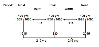
Figure 3: Cycle of colder and warmer winters
As indicted before, higher and stronger dikes do not protect against ice jams and therefore Berveas suggested that alternatives should be found to deal with the potential consequences of ice jams.12However, there are additional reasons why it would be advisable to look at alternative solution to protect land and people from river flooding. Furthermore, the chances that ice dams form are small at present due to cooling water discharge and busy shipping.13 In addition it has been shown more recently that river flood frequency is difficult to ascribe to singular causes and that natural phenomena as well as human interference interact in complicated ways.14
Alternatives to dike reinforcement
Due to urbanisation and climate change, peak discharges have been increasing both in size and in frequency since the 1980s. Over the last decade some serious flooding in the Dutch river area has shown the necessity of action. To mitigate the effects of urbanisation and climate change, it is proposed to reintroduce some of the historical flexible river defence systems as well as more modern solutions such as local retention of water to combat high peak discharge. Local water retention is a system based on the construction of retention basins that can be used to store water during periods of high water. When the floods subside the water is drained from the basin. The downside of this river is that it only reduces the peak discharge downstream but it does not increase the discharge capacity of the rivers (figure 4).

Figure 4: Diagram of a retention basin
Another way of reducing peak discharge is to slow the flow of water down. Widening the foreland and encouraging vegetation in these areas can achieve this. The first measure will increase the capacity of the river and the latter slows the flow of water down decreasing the peak discharge downstream.
Overflow channels and lateral diversions do increase the capacity of the rivers and it has been proposed to create new lateral diversions. However in a densely populated country like the Netherlands it is difficult to do so since this means flooding periodically agricultural land or even residential areas that are in route of the lateral diversions. Therefore these channels must be planned carefully and farmers compensated for the inundation of their land for longer periods. Residential areas can be protected with low levies surrounding them and newly build solitary houses could be places on low hills to lift them above the flood plain. After the near flood catastrophe of 1995 a beginning was made in constructing low levies around settlements.15
Lateral diversions, flood hills and increasing the foreland are all concepts that have been successfully used in the past. It is ironic that at the present engineers are looking to the past and reintroduce a flexible approach to river flood defences. Historical concepts mixed with modern knowledge and techniques results in new ways of flood protection that assures the safety of people but also secures the cultural heritage in the river land of the Netherlands.16
References
2 Tol, Richard S.J. and Langena, Andreas, “A Concise History of Dutch River Floods”, Climatic Change 46 (2000), 361-362.
3 G.P. van de Ven, (ed.), Man-made Lowlands, p. 170.
4 R. Havinga et al., “Overlaten en Groene Rivieren: Geschiedenis of Toekomst? “, H2O 10 (1992), 482.
5 Berveas, J., “Memoires van de Discussie over Dijkverzwaring”, in: Berveas et al., Landschap als geheugen. Opstellen tegen Dijkverzwaring (Amsterdam: Cadans, 1993).
6 Velde, B. van der, “Het laatste Waterplasje”, in: J. Berveas et al., Attila op de Bulldozer. Rijkswaterstaat en het Rivierengebied (Amsterdam: Oorschot, 1990), p. 35.
7 Berveas, J., “Memoires van de Discussie over Dijkverzwaring”, p. 45.
8 Toorn, W. van der, “Inleiding”, in: Berveas et al., Landschap als geheugen, p. 3.
9 Ibid.; Goudriaan, H., “Sluipmoord op het Cultuur landschap”, in: Berveas et al., Landschap als geheugen, pp. 85-87.
10 Berveas, “Memoires”, p. 46.
11 Berveas, J., “IJsgang oorzaak van overstromingen”, Land & Water 10 (December 1990).
12 Berveas, J., “De Waal bij Zaltbommel in de periode 1832-1983. Oorzaken overstromingen”, draft article for Van Vooren tot Loevestein published by the “Historische Kring Bommelerwaard”.
13 van de Ven, Man-made Lowlands, p. 28.
14 See discussion in: Glaser R. and H. Stangl, “Historical floods in the Dutch Rhine Delta”, Natural Hazards and Earth System Sciences 3 (2003), 605–613.
15 Van de Ven, Man-made Lowlands, p. 364.
16 For more information about flood protection in historical perspective see: http://www.geo.uu.nl/fg/palaeogeography/results/flooding.
Listen to Exploring Environmental History podcast episode 5 and learn more about river flooding in the Netherlands
Recent Comments